
Navionics vs. Wavve Boating: Why Wavve Boating is the Best Choice
Image courtesy of Ahmet Kurt @ Pexels.com
Introduction: Why Wavve Boating Stands Out
For years, Navionics has been one of the most recognized names in marine navigation, offering advanced tools for professional mariners and offshore navigators. However, not every boater needs complex, outdated interfaces and difficult-to-navigate menus.
Enter Wavve Boating—a modern, intuitive, and community-driven marine navigation app that’s built specifically for recreational boaters. If you’ve ever found yourself frustrated by Navionics’ overwhelming interface or lack of social features, Wavve Boating is the refreshing alternative you’ve been looking for.
This guide compares Navionics and Wavve Boating head-to-head, showing why Wavve Boating is the better choice for most recreational boaters, weekend cruisers, and casual explorers.
Wavve Boating Overview
What is Wavve Boating?
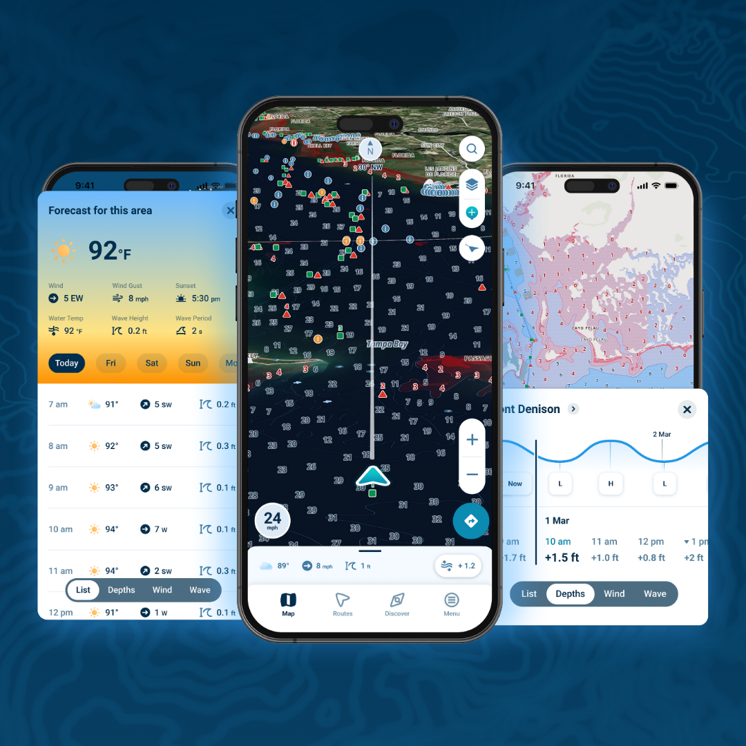
Wavve Boating is a game-changing marine navigation app built for modern boaters. Instead of focusing on overly technical features, Wavve Boating prioritizes simplicity, usability, and real-time community engagement—making it the best choice for recreational boating.
Key Features and Capabilities
- User-friendly, clutter-free interface that’s easy to navigate. User feedback ensures the Wavve app is simple to use for all types of boaters, regardless of expertise.
-
Smart auto-routing
that works like Google Maps for the water. Wavve considers real-time data, like weather and tides, as well as local regulations to provide the most efficient and safe route for your journey.
-
Real-time social features
to share routes, locations, and discoveries.
- Depth shading and shallow water alerts to avoid hazards. You can also set up alerts for a specific depth, so you’re always aware of potential hazards.
- Tide, weather, and marine conditions in one place. View real-time marine and weather data—including wind speed and direction, wave height, and water temperature—at your fingertips.
- Offline mode with battery-efficient functionality. Access all your routes, locations, and marine data without using data or draining your battery.
Subscription and Pricing Options
Wavve Boating offers a simple, affordable pricing models with no hidden costs. Unlike Navionics, you don’t need to buy multiple regions or pay extra for premium features—you get everything in one plan
Why Wavve Boating is the Smarter Choice
-
Easy to use, even for first-time boaters.
Wavve’s user-friendly interface and intuitive features make it easy for anyone to navigate the water with confidence.
- No overwhelming menus or technical jargon. The app is designed to simplify the boating experience for all users.
- More than just a navigation app—it’s a boating community. With features like real-time location sharing, event planning, and messaging, Wavve brings boaters together and enhances the overall experience on the water.
- Does everything Navionics does—but better, simpler, and smarter. Wavve offers all the essential features of Navionics, but with a more user-friendly interface and additional real-time data. It’s the best of both worlds for boaters looking for a reliable navigation tool.
Minimal Drawbacks
- Not built for commercial operators or demanding offshore sailing. While the Wavve app provides a strong set of tools for recreational boaters, it may not fully satisfy the specialized needs of professional mariners or those navigating extreme offshore conditions.
- Some features, such as chart layering, are still evolving. Wavve already offers a solid range of chart layers, but there is still room for further expansion and refinement. That said, the Wavve team continues to actively improve the platform and roll out new features over time.
Navionics Overview

Image courtesy of: Garmin.com
What is Navionics?
Navionics is a feature-packed marine navigation app that offers detailed nautical charts, route planning, and GPS integration. It’s widely used by serious mariners and is owned by Garmin, making it a go-to choice for professional navigation.
Key Features and Capabilities
- Global nautical chart coverage for coastal and inland waters. Navionics’ comprehensive charts for boaters around the world—including oceans, lakes, and rivers—make it a top choice for navigating in various locations.
- Auto-routing technology to create suggested paths and track progress in real-time.
- SonarChart bathymetric mapping for depth visualization—particularly useful for angling and anchoring.
- Satellite overlays and relief shading for better map detail. High-resolution imagery gives boaters a more realistic view of their surroundings.
- Tide and current information to help with trip planning. Access up-to-date weather forecasts and tide information within the app —helps users make informed decisions on when and where to go out on the water.
Subscription and Pricing Options
Navionics follows a subscription model, with regional pricing plans:
- Navionics+: Basic charting and navigation tools.
- Navionics Platinum+: Premium features like satellite imagery and 3D views.
Strengths of Navionics
- Comprehensive chart coverage with frequent updates. Navionics has one of the largest databases for nautical charts in the world, covering over 80 countries with more than 40,000 lakes and rivers. And the app is updated regularly with new information.
- Detailed bathymetric maps and sonar charting. This granular data offers users a more accurate understanding of underwater terrain.
- Integrates well with Garmin and Lowrance devices. The app also allows for data transfer between devices, making it easy to plan trips on the go.
Drawbacks of Navionics
- Cluttered, outdated interface that’s difficult for casual users.
- Steep learning curve. With so many features and capabilities, it may take some time and effort for users to become familiar with all of Navionics’ functions..
- Limited offline capabilities. While Navionics does offer offline charts, they are limited compared to the online versions.
- Expensive subscription model with additional feature costs.
Navionics vs. Wavve Boating: Head-to-Head Comparison
| Feature | Navionics | Wavve Boating |
|---|---|---|
| Chart Accuracy | Excellent, global coverage | Excellent, real-time depth shading |
| Auto-routing | Yes, but complex | Yes, simple and intuitive |
| Offline Functionality | Yes, requires downloads | Yes, battery-efficient |
| Social Features | Crowd-sourced updates, ability to share via social | Live sharing, community markers |
| User Experience | Outdated, cluttered | Clean, beginner-friendly |
| Subscription Model | Expensive, multiple regions | Simple, one tier of service |
How Wavve Boating Makes Navigation Simpler for Recreational Boaters
For most recreational boaters, navigation should feel simple and stress-free. That’s where Wavve Boating really stands out. Instead of forcing users to learn complicated chart tools or navigate cluttered menus, Wavve focuses on delivering the information boaters actually need in a clean, easy-to-understand format. Features like smart auto-routing, real-time marine conditions, and clear depth shading help users quickly plan safe routes and stay aware of hazards without getting overwhelmed by technical settings. The result is a navigation experience that feels intuitive from the first use, whether you’re planning a weekend cruise, exploring a new lake, or heading to a favorite sandbar.
Final Verdict: Which One is Better for You?
If you’re looking for a frustration-free boating experience, Wavve Boating is the clear winner.
- It’s easier to use. No complicated menus, just simple, smart navigation.
- It’s more social. Share routes, mark locations, and connect with other boaters.
- It’s affordable. One tier of service, no hidden fees, and no need to buy separate chart regions.
For most recreational boaters, Wavve Boating is simply the better choice.
Other Marine Navigation Apps to Explore
- Aqua Map – Good for depth-based navigation.
- C-MAP – A solid alternative with international charts.
- LakeMaster – Great for fishing-focused navigation.
FAQs
Is Wavve Boating easier to use than Navionics?
Yes. Navionics can be overwhelming, while Wavve Boating is simple, intuitive, and beginner-friendly.
Can Wavve Boating be used for serious navigation?
Absolutely. It has smart auto-routing, tide and weather data, and offline functionality.
Which app has better social features?
Only Wavve Boating offers live sharing, location markers, and community-based features.
Does Wavve Boating work offline?
Yes. You can download maps and use them even when there’s no signal.
Try Wavve Boating for Free – No Sign-Up Required!
If you want a modern, easy-to-use, and smarter alternative to Navionics, download Wavve Boating today and try it for free.
Content
- Navionics vs. Wavve Boating: Why Wavve Boating is the Best Choice
- Introduction: Why Wavve Boating Stands Out
- Wavve Boating Overview
- Navionics Overview
- Navionics vs. Wavve Boating: Head-to-Head Comparison
- How Wavve Boating Makes Navigation Simpler for Recreational Boaters
- Final Verdict: Which One is Better for You?
- Other Marine Navigation Apps to Explore
- FAQs


