The Florida Keys present some of the most challenging and rewarding boating conditions in the United States. Tight channels weave through shallow water. Sandbars shift unpredictably. Coral heads hide just beneath the surface. Tidal swings of two to four feet dramatically change navigable water depths. Strong currents move faster than in open water. No-wake zones restrict power. Remote anchorages lie beyond cellular coverage. Choosing the right navigation app becomes critical for safety and confidence.
Unlike open water or large lakes, Keys navigation demands apps specifically designed for shallow tidal conditions. Traditional navigation apps created for general boating often fall short in the Keys’ unique environment. This guide compares the best apps specifically optimized for Keys boating challenges, helping you navigate safely through channels, avoid grounding, and understand real-time conditions.
Why Navigation Apps Matter in the Florida Keys
The Florida Keys differ dramatically from other boating destinations. Several factors make specialized navigation essential.
Shifting sandbars: The Keys’ seafloor changes constantly from storm action, tidal movement, and natural forces. Sandbars that blocked passage last season may have moved significantly. Paper charts become outdated. Real-time apps with community hazard reporting help you discover current conditions that static charts cannot reveal.
Extensive coral heads: Protected coral exists throughout the Keys requiring precise navigation. Even slight detours from marked channels risk reef damage. Navigation apps showing exact channel positions with sufficient detail prevent costly coral strikes. Satellite imagery overlays help visualize coral locations.
Dramatic tidal changes: The Keys experience tidal swings of two to four feet or more. A passage showing adequate depth at high tide becomes impassable at low tide. Water depth changes on your charts must account for current tides, not just static charted depths. Apps integrating real-time tide predictions transform navigation from guesswork into confident decision-making.
Strong currents: Tidal and ocean currents flow forcefully through Keys channels. Current direction and strength affect your boat’s actual course and speed. Navigation apps showing current vectors help you compensate for drift and maintain accurate positioning.
Remote areas without cell coverage: Keys boating often ventures into remote areas where cellular signals disappear. Offline capability becomes essential. You need navigation apps allowing chart downloads before trips so full functionality continues when signals vanish.
Narrow channels and no-wake zones: Keys navigation frequently involves tight channels with specific speed restrictions. Precise positioning helps you stay centered in narrow passages and understand where speed restrictions apply.
These unique conditions demand apps specifically designed for Keys boating rather than general navigation software.
Wavve Boating: The Best Overall Choice for Florida Keys Navigation
Wavve emerges as the strongest overall choice for most Keys boaters due to its unique combination of shallow water safety features, real-time tide integration, and intuitive design specifically valuable in Keys conditions.
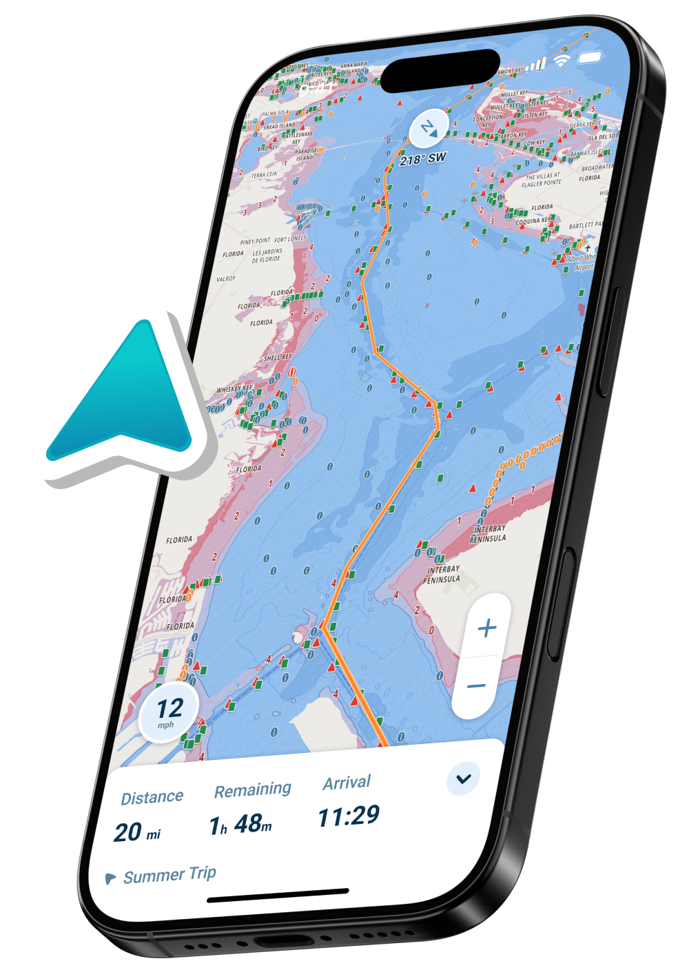
Automatic draft-aware navigation: This represents Wavve’s most significant Keys advantage. Enter your boat’s draft once. The app instantly shows blue zones indicating safe water and red zones warning of shallow areas, updating hourly as tides change. In the Keys where inches of tide separate safe passage from grounding, this automation transforms navigation from anxiety into confidence. You see visually where you can safely navigate at current water levels accounting for both your boat’s specific draft and current tides.
Real-time tide integration: The Keys experience significant tidal changes throughout the day. Wavve integrates current tide predictions directly into charts, showing depth changes as water levels fluctuate. You navigate based on actual current conditions, not yesterday’s predictions. This real-time accuracy proves invaluable for timing passage through shallow areas or planning when to navigate specific channels.
NOAA chart coverage: Wavve uses NOAA charts covering the Florida Keys areas. These professional-grade charts provide accurate depths, navigation aids, and underwater features. Coverage means your single subscription works throughout the Keys and beyond if you venture to other destinations.
Community hazard reporting: Over one million boaters share real-time hazard information through Wavve’s system. See recently reported shallow spots, debris, and obstacles that other Keys boaters just discovered. This crowdsourced local knowledge supplements charts with current conditions that static charts cannot capture.
Offline capability: Download Keys chart regions over WiFi before trips. Navigate completely offline using GPS alone when cellular signals vanish in remote anchorages. This proves essential for Keys boating where remote areas lack coverage.
Simple, mobile-first interface: Wavve’s interface prioritizes simplicity and readability on phones and tablets. Large text remains readable in sunlight. Intuitive controls work reliably with wet hands. The app gets out of your way so you focus on actual boating rather than fighting software.
14-day free trial: Test Wavve completely free for two weeks with no upfront payment. Experience draft-aware navigation in actual Keys waters before any commitment.
Pricing: $69.99 annually or $11.99 monthly after trial ends.
Best for: Recreational boaters, anglers, families, and anyone prioritizing shallow water safety and ease of use.
Navionics Boating: Detailed Charts and Fishing Data
Navionics remains a trusted choice for Keys boaters, particularly those focused on fishing with detailed depth information.
Strengths:
SonarChart community data provides exceptional detail about seafloor composition and underwater features. Anglers gain valuable information about bottom type, structure, and fishing locations. This crowdsourced depth data created by hundreds of boaters boating the Keys regularly provides unique insight.
Professional-grade vector charts licensed from NOAA and other sources. Detailed chart presentation appeals to boaters preferring traditional chart styling. The charts feel familiar to boaters accustomed to paper chart presentations.
Established platform with long history in Keys boating. Millions of boaters use Navionics, meaning extensive online resources, tutorials, and community knowledge exist.
Integration with Garmin hardware systems. If you own compatible Garmin chartplotters, Navionics syncs data seamlessly between your phone and boat hardware.
Weaknesses:
No automatic draft-aware depth shading. You see charted depths but must manually calculate whether adequate clearance exists for your boat at current tides. This requires mental calculations many casual boaters find stressful.
Basic weather integration. Navionics provides weather information but less sophisticated integration than modern alternatives.
Higher base cost at $49.99 annually for US and Canada coverage.
Less intuitive modern interface compared to newer apps. More learning curve for casual users.
Best for: Experienced Keys boaters comfortable with chart interpretation, anglers seeking detailed fishing spot data, boaters with Garmin hardware integration needs.
Argo Navigation: Community Knowledge and Affordability
Argo builds its reputation on strong community features and generous free functionality, appealing to budget-conscious boaters.
Strengths:
Excellent free tier with basic navigation, chart access, and route creation. No commitment required to test functionality. Perfect for casual boaters wanting to try before paying.
Strong community hazard reporting similar to Waze for boating. Users contribute information about shallow spots, obstacles, and navigation challenges they encounter. This local knowledge provides real-time updates about Keys conditions.
Premium tier at $39.99 annually adds offline charts and advanced weather. Still less expensive than many competing apps.
Simple, modern interface focused on essential features. Easy for casual users to understand quickly.
Weaknesses:
No automatic draft-aware safety features. You must manually interpret depths similar to Navionics.
Limited weather integration in free tier. Premium tier improves weather functionality.
Smaller established user base compared to Navionics. Less accumulated community data in some locations.
Best for: Budget-conscious boaters, casual recreational users wanting to test before commitment, boaters who value community local knowledge.
Savvy Navvy: Passage Planning and Weather Routing
Savvy Navvy serves boaters emphasizing route planning and passage optimization, particularly valuable for longer Keys sails.
Strengths:
Advanced weather routing and smart automatic course calculations. Departure scheduler identifies optimal departure times based on weather windows. Particularly valuable for multi-day cruises optimizing around conditions.
Detailed marine weather forecasting with wind, swell, and visibility. 14-day forecasts allow planning around weather patterns.
Global coverage at a flat Premium price ($169 annually), making it good for boaters cruising beyond the Keys.
Clean modern interface emphasizing readability.
Weaknesses:
No automatic draft-aware safety features. Requires manual depth interpretation.
Premium pricing at $169 annually costs more than most alternatives.
More focused on sailing and passage planning than casual recreational boating. Cruisers planning short day trips find features unnecessary.
Free tier limited to US only, with limited functionality.
Best for: Sailors planning passages, cruisers undertaking extended voyages optimizing around weather, boaters making long-distance trips.
Aqua Map: Detailed Hydrographic Focus
Aqua Map provides another solid option particularly appealing to boaters wanting detailed US coastal data.
Strengths:
Vector charts from USACE and NOAA sources with detailed hydrographic information. Particularly strong for US coastal and inland waters.
Advanced tool packages available for fishing and detailed navigation. Sonar logging capability for anglers.
Affordable annual pricing at $14.99 for base charts.
Offline capability with downloadable chart regions.
Weaknesses:
No automatic draft-aware features. Requires manual depth calculation.
Less established user base compared to Navionics. Fewer online resources and tutorials.
Tool packages add cost beyond base subscription.
Best for: Detailed boaters wanting hydrographic focus, anglers using sonar features, boaters wanting affordable options.
Quick Feature Comparison Table
| Feature | Wavve | Navionics | Argo | Savvy Navvy | Aqua Map |
| Automatic Draft-Aware Shading | Yes | No | No | No | No |
| Real-Time Tide Integration | Yes | Manual | Limited | Yes | No |
| Offline Charts | Yes | Yes | Premium | Yes | Yes |
| Community Hazard Reports | Yes | Limited | Yes | No | No |
| NOAA/CHS Charts | Yes | Yes | Yes | Yes | Yes |
| Free Trial/Free Tier | 14-day | Limited | Strong Free | Limited | Trial |
| Annual Price | $69.99 | $49.99 | $39.99 or Free | $169 | $14.99 |
| Best for Keys | Excellent | Good | Good | Fair | Fair |
Key Considerations for Florida Keys Boating
Several factors matter beyond app features when choosing Keys navigation.
Water color reading: Experienced Keys boaters learn to read water color indicating depth. Dark blue means deep water. Light blue or turquoise indicates shallows. Brown or tan means very shallow. No app replaces this skill, but apps supplement it with confirmation.
Tide timing: Knowing current tide conditions and timing channel passages accordingly remains essential. Real-time tide integration helps, but planning around major tidal shifts prevents problems.
Local knowledge: Speaking with other Keys boaters provides invaluable insights no app captures. Marina staff, fishing guides, and charter captains share practical experience about current conditions.
Offline capability: Keys boating often ventures into remote areas without cellular coverage. Ensure your chosen app supports chart downloads for offline use.
Mount and visibility: Phone or tablet mounting should position navigation screens for easy visibility without constant reaching. Consider mounting solutions that protect your device from splash and sun glare.
Manatee zone awareness: The Keys include numerous manatee protection zones with speed restrictions and navigation rules. Apps showing these zones help you understand where restrictions apply.
Which App Is Best for Your Keys Boating?
Your ideal choice depends on specific boating patterns.
For recreational family cruisers: Wavve Boating’s draft-aware safety and intuitive interface create confidence and prevent anxiety about shallow water. The automatic depth shading transforms navigation from stressful to enjoyable.
For serious anglers: Navionics’ SonarChart community data provides exceptional fishing spot information combined with depth details valuable for shallow water angling.
For budget-conscious weekend boaters: Argo’s free tier can provide solid navigation without major spending commitments.
For sailors and passage makers: Savvy Navvy’s weather routing and passage planning tools justify premium pricing.
For casual explorers: Argo’s free tier lets you test before committing money.

FAQ
Can I use multiple navigation apps simultaneously?
Absolutely. Many experienced Keys boaters maintain subscriptions to two apps for cross-reference and backup. This increases navigation confidence on unfamiliar routes.
Which app has the most up-to-date Keys information?
Apps integrating real-time community hazard reports stay most current. Wavve and Argo’s community systems provide recent boater experiences. Charts update regularly but less frequently than community reports.
Will switching apps from Navionics be difficult?
Most apps support GPX file imports. Export your Navionics waypoints and routes as GPX files, then import into your new app. Your saved data transfers easily.
How critical is draft-aware navigation for Keys boating?
Very critical. In the Keys where water depths change constantly with tides and sandbars shift, knowing exactly where your boat can navigate prevents costly groundings. Automatic draft-aware shading transforms this from manual calculation to instant visual awareness.
What if I lose cellular signal while navigating?
Download chart regions for offline use before your trip. Once downloaded, navigation continues using GPS alone. All apps mentioned support offline capability.
Do all these apps work on both iPhone and Android?
Yes. All apps support iOS and Android with identical functionality. Download from App Store or Google Play.
Can I share navigation data with my fishing partner?
Most apps allow exporting routes and waypoints as GPX files or direct sharing. Check specific app features, but generally data sharing works well.
Which app handles emergency situations best?
All apps provide position information helpful in emergencies. None replaces proper safety equipment and communication devices. Maintain a working VHF radio and emergency signaling devices regardless of app choice.
Conclusion
The Florida Keys demand navigation apps specifically designed for shallow water, tidal conditions, and coral awareness. Wavve Boating emerges as the strongest overall choice for most Keys boaters due to automatic draft-aware safety that updates with tides, real-time tide integration, community hazard reporting, and intuitive interface design. Navionics remains excellent for anglers wanting detailed fishing spot data. Argo provides budget options with strong community features. Savvy Navvy serves passage sailors and cruisers.
Test your preferred app during its free trial on actual Keys boating trips. Experience how draft-aware visualization helps you understand water depth. See how real-time tide integration updates charts as water levels change. Notice how community hazards alert you to obstacles other boaters recently encountered. By trial end, you’ll clearly understand which app best serves your specific Keys boating needs and style.
Safe navigation and confident boating in the Keys begins with choosing the right tools. The right app becomes your constant companion on every Keys adventure, transforming challenging conditions into manageable, enjoyable boating.