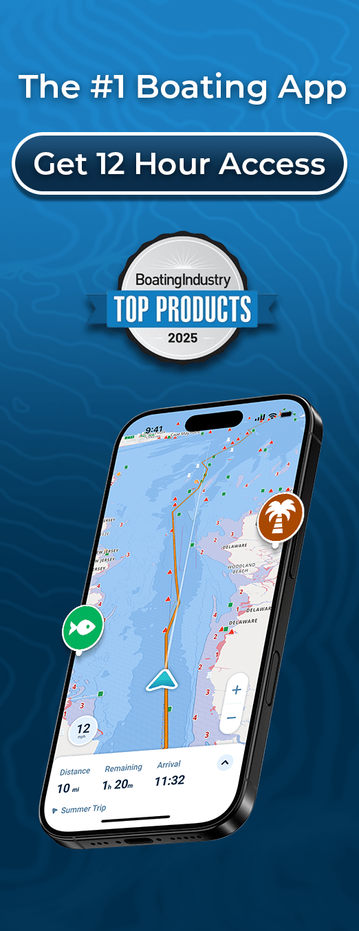
Hourly wave heights, 7-day forecasts, and real-time wave period data displayed directly on your marine charts for safer, clearer navigation.
Wave conditions can change fast, and understanding those shifts is essential for safe, comfortable boating. The Wavve Height App, part of the full navigation experience inside Wavve Boating, gives you real-time awareness of wave height, swell timing, and upcoming marine conditions without needing to switch between multiple tools. Everything you need lives in one clean, modern interface designed for everyday boaters.
Whether you’re studying conditions through the Wavve Chart Viewer, planning a weekend on the water, or learning more through the Wavve Boating Blog, Wavve makes marine forecasting simple, visual, and easy to understand.
Why Wave Height Matters for Every Boater
Wave height doesn’t just shape comfort, it dictates safety, speed, and whether a route is suitable for your vessel.
Sudden swell increases can make a calm trip uncomfortable, dangerous, or impossible, especially for PWCs, small craft, and coastal cruisers. Traditional weather apps show generic offshore forecasts, but they rarely pair that data with real navigation context.
The Wavve Boating platform fills that gap by integrating wave height, tides, depth, and wind data directly onto your marine chart. You get a complete picture of what’s happening now, and what’s coming next, in a format built for fast decision-making on the water.
What Makes the Wavve Height App Different
Instead, Wavve brings live wave height, swell period, and 7-day forecasts into a single, unified navigation experience.
Built by boaters for boaters, Wavve focuses on clarity and real-time awareness. You can explore this approach to marine simplicity on the Wavve About Page, or dive into feature specifics through Wavve app features.
With Wavve, forecasting becomes visual and intuitive, not technical.
Hourly Wave Height Data for Real-Time Marine Awareness
See changing wave conditions hour by hour directly on your navigation chart
Wave conditions shift constantly, and Wavve ensures you never miss a change. The app updates wave height every hour, displaying clear swell data directly on your chart view. This helps boaters choose the safest departure times, avoid rough patches, and understand how conditions evolve throughout the day. Everything is integrated into the same interface you use to route, navigate, and explore, no switching apps, no decoding marine text reports.
Seven-Day Wave Forecasts That Simplify Trip Planning
Plan confidently with week-long wave predictions layered right onto your map
Whether you’re preparing for a fishing weekend, planning a longer route, or choosing the best day to take out the family, Wavve’s 7-day wave forecast helps you see patterns clearly. Forecasted wave heights, trends, and upcoming swell shifts appear directly on your navigation chart, making long-range planning simple and precise. This visibility helps avoid bad-weather surprises and ensures you pick the best windows for smooth, safe trips.
Real-Time Wave Period Insights for Smoother, Safer Trips
Understand how wave timing affects comfort, safety, and vessel performance everywhere
Wave height tells you how big a swell is, wave period tells you how it feels. Longer-period waves create smoother, rolling motion, while short-period waves lead to choppy, uncomfortable, and sometimes dangerous conditions. The Wavve Height App displays real-time wave period data directly on your chart, helping you assess ride quality before you depart. It’s essential information for PWCs, center consoles, offshore boats, and anyone who wants a safer, more predictable trip.
Integrated Wave, Weather, and Tides in One Unified View
See marine conditions layered together seamlessly on your navigation screen
Instead of switching between multiple forecasting tools, Wavve brings wave height, wave period, wind patterns, and tide data onto the same map you navigate with. This unified view helps you understand the full marine picture instantly: how waves interact with tides, how wind shapes conditions, and how all these elements impact your route. The result is smarter planning, clearer decision-making, and a navigation experience designed for real-world conditions.
Explore how these layers work together through Wavve app features.
Personalized Forecasting Tailored to Your Vessel Type

Get wave and weather insights optimized for your boat’s unique handling profile
Not all boats react to waves the same way. A 28-foot cruiser and a jet ski can experience the same swell very differently. The Wavve Height App lets you personalize your vessel settings so the information shown reflects your craft’s handling and draft. This ensures forecasted conditions are meaningful, relevant, and easier to act on, especially when navigating unfamiliar waters or planning longer-distance routes.
Reliable Wave Data Anywhere With Offline Chart Access
Download charts and forecasts to stay prepared even far from cell coverage
Boaters often travel beyond cell or Wi-Fi range, and Wavve ensures your wave data never disappears when you need it most. You can download charts, forecasts, and essential marine layers for offline use. Once on the water, your app remains fully functional, showing stored wave height and route information without interruption. When signal returns, everything updates automatically.
Preview chart coverage through the Wavve Chart Viewer.
Community Insights Enhance Every Forecast You See
View real boater updates layered alongside official wave and weather data
Wavve combines official marine data with real-world reports from active boaters, something traditional forecasting tools lack. Users share updated conditions, hazards, sandbars, and tips that add valuable context to wave forecasts. This community-driven layer gives you a clearer sense of what’s happening right now, not just what’s predicted. For trip ideas and location-specific insights, explore the Wavve Boating Blog.
Why Wavve Is the Best Wave Height App for Boaters
Wavve brings clarity to marine conditions by delivering:
- Hourly wave height updates
- A full 7-day wave forecast
- Real-time wave period intelligence
- Integrated weather, tide, and depth data
- Offline chart access
- Vessel-specific insights
- Community-driven reporting
Everything works together in one modern, intuitive interface built specifically for boaters. No clutter. No technical charts. Just accurate, actionable information when you need it most.
Get Real-Time Wave Height & Marine Forecasts With Wavve Boating
The Wavve Height App helps you understand conditions before you leave the dock, and while you’re on the move. Wave height, wave period, tides, wind, and depth all come together in one clear, reliable platform designed for safer navigation.
Explore Wavve’s full capabilities through Wavve Boating and navigate with confidence wherever your trip takes you.
Download Wavve Boating – Navigate With Confidence
FAQ
What’s the difference between wave height and wave period?
Wave height measures the vertical size of a wave, while wave period describes the time between each wave. The Wavve Height App displays both so boaters understand not only how big waves are but how they’ll feel. Longer periods mean smoother rides; shorter periods create choppy, uncomfortable conditions.
How often does Wavve update wave height information?
Wave height data updates hourly, giving boaters real-time awareness of changing conditions. You can view these updates directly within your navigation chart through Wavve Boating.
Does the Wavve Height App include a 7-day forecast?
Yes. Wavve provides a full 7-day wave forecast layered onto your marine map. This helps boaters plan fishing trips, offshore passages, and weekend outings more confidently.
Can I use wave height features offline?
Absolutely. You can download charts and marine forecasts for offline use. Once saved, your wave, tide, and navigation data continue working even beyond signal range.
Is the wave period data useful for all boat types?
Yes, especially for smaller vessels, PWCs, and offshore cruisers. Wave period is one of the most important indicators of ride comfort, and Wavve makes it easy to understand right on your chart.
Is Wavve easier to use than other marine weather apps?
Yes. Wavve is designed for clarity, speed, and simplicity. Instead of technical marine reports, you get visual, easy-to-read wave and weather conditions tailored to your boat. Learn more on the Wavve About Page.
How accurate is the wave height data in Wavve?
Wavve sources data from trusted marine forecast models and updates it hourly. Combined with real boater insights and on-chart visualization, the result is one of the most practical, real-world wave forecasting tools available.
Content
- Hourly wave heights, 7-day forecasts, and real-time wave period data displayed directly on your marine charts for safer, clearer navigation.
- Why Wave Height Matters for Every Boater
- What Makes the Wavve Height App Different
- Hourly Wave Height Data for Real-Time Marine Awareness
- Seven-Day Wave Forecasts That Simplify Trip Planning
- Real-Time Wave Period Insights for Smoother, Safer Trips
- Integrated Wave, Weather, and Tides in One Unified View
- Personalized Forecasting Tailored to Your Vessel Type
- Reliable Wave Data Anywhere With Offline Chart Access
- Community Insights Enhance Every Forecast You See
- FAQ
- What’s the difference between wave height and wave period?
- How often does Wavve update wave height information?
- Does the Wavve Height App include a 7-day forecast?
- Can I use wave height features offline?
- Is the wave period data useful for all boat types?
- Is Wavve easier to use than other marine weather apps?
- How accurate is the wave height data in Wavve?