Marine charts remain essential for safe navigation, but buying options have evolved dramatically from the days of bulk-printed paper charts and expensive chartplotter cards. Official sources like NOAA for U.S. waters and the Canadian Hydrographic Service for Canada now offer free digital Electronic Navigational Charts (ENCs), Print-on-Demand paper options, and seamless integration in subscription apps that update automatically.
Understanding where to buy marine charts and which format best suits your boating needs helps ensure you’re navigating with accurate, current information while avoiding unnecessary costs. This comprehensive guide examines all available options from free official downloads to modern app subscriptions, helping you make informed decisions about chart purchases.
Understanding Marine Chart Types
Before purchasing charts, understanding the different formats helps match options to your needs. Paper charts provide traditional, tactile backups that work without electronics, valuable for offshore passages or emergency situations when all electronics fail. Raster charts represent scanned versions of paper charts displayed electronically, showing identical information in digital format. Vector or ENC charts (Electronic Navigational Charts) offer interactive digital charts with layered information, adjustable detail levels, and integration with GPS systems, the preferred format for modern apps and chartplotters.
Official charts matter significantly for both legal compliance and accuracy. NOAA charts for U.S. waters and CHS charts for Canadian waters represent authoritative hydrographic surveys meeting international standards. Recreational boaters in U.S. waters aren’t legally required to carry official charts, but commercial vessels and prudent recreational boaters recognize their value for safe navigation.
Where to Buy Marine Charts: Complete Options
Wavve Boating
Cost: $69.99/year ($11.99/month option)
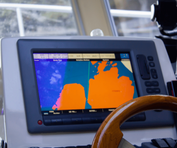
Wavve Boating includes 17,000+ official charts worldwide (NOAA, CHS, AHO, UKHO) in one subscription covering U.S., Canadian, Australian, and UK waters without regional purchases. The platform distinguishes itself through integrated safety features specifically addressing recreational boater needs.
Draft-aware depth shading automatically color-codes charts showing safe (blue) versus shallow (red) water based on your vessel’s specific draft plus real-time tide levels. Enter your boat’s draft once, and the system continuously updates depth visualization as tides change, eliminating manual calculations about whether charted depths provide adequate clearance.
Seven-day marine weather forecasts layer directly on charts with hourly wind, wave, and condition predictions. Real-time tide integration adjusts displayed depths throughout the day. Community hazard reporting allows boaters to share current information about navigation hazards, relocated markers, or discovered anchorages.
Full offline downloads ensure navigation works without cell coverage after downloading chart regions. Automatic updates include latest chart corrections without additional purchases. Track recording, smart autorouting considering vessel draft, and Sea-Doo display integration round out the feature set.
The all-inclusive approach means no separate chart purchases ever, one subscription covers worldwide official charts plus all safety and navigation features.
Advantages of App-Based Charts: Continuous automatic updates included, offline downloads for remote areas, mobile portability across devices, integrated weather and tide data, draft-aware safety features (Wavve), community intelligence, no storage space needed, works on devices you already own.
Limitations: Requires smartphone or tablet, annual subscription costs, depends on device battery life, screen visibility in bright sunlight varies by device.
Best For: Most recreational boaters, those wanting current charts without managing updates, mobile platform users, boaters navigating shallow waters needing draft awareness, anyone preferring integrated navigation solutions.
Official Free Digital Downloads (NOAA ENC)
Source: NOAA Coast Survey website (charts.noaa.gov)
Cost: $0
NOAA provides free Electronic Navigational Chart downloads covering all U.S. waters including coastal areas, Great Lakes, and major inland waterways. These official digital charts represent the same data used in professional navigation systems and update regularly to reflect latest hydrographic surveys and Notice to Mariners corrections.
How to Download: Visit charts.noaa.gov, select your region, and download individual charts or regional packages. Files come in S-57 ENC format compatible with most marine navigation software.
Advantages: Always free, continuously updated by NOAA, works with compatible navigation software and apps, represents official authoritative data.
Limitations: Requires compatible software or apps to view and use the chart files. Raw ENC files don’t provide user-friendly interfaces without supporting applications. No physical paper backup.
Best For: Boaters comfortable with technology who already use navigation software or apps supporting ENC format, those wanting to verify chart data in multiple applications, budget-conscious navigators.
Print-on-Demand Paper Charts
Authorized Sources: OceanGrafix, NOAA Chart Shop (Paradise Cay Publications), NauticalChartsOnline, West Marine, Captain’s Nautical Supplies, Maptech
Cost: $20-50 per chart
Following NOAA’s transition from bulk lithographic printing to Print-on-Demand (POD) in 2020, certified agents now print official NOAA charts incorporating all latest Notice to Mariners corrections up to the print date. This system ensures every purchased chart reflects current data rather than sitting in warehouse inventory for months.
How It Works: Order specific chart numbers online from authorized POD agents. Charts print on-demand with latest corrections incorporated, then ship within 1-3 business days. Many vendors offer both traditional paper and waterproof versions.
Chart Options:
- Full-size traditional paper ($20-30 per chart)
- Waterproof paper ($30-50 per chart)
- Booklet/folded formats for easier storage
- Laminated versions for durability
Advantages: Physical backup requiring no electronics, waterproof options available, incorporates latest corrections at print time, tactile plotting capabilities, multiple format choices.
Limitations: One-time purchase per chart, updates require buying new versions. Regional coverage requires multiple chart purchases adding significant cost. Storage space needed for physical charts.
Best For: Offshore cruisers wanting reliable backups, boaters preferring traditional navigation methods, those operating in areas where electronic failure poses serious safety concerns, complementary backup to electronic navigation.
Understanding where official charts are available helps plan purchases. NOAA covers U.S. coastal waters, Great Lakes, and major navigable inland waterways. Canadian Hydrographic Service charts cover Canadian waters through similar POD systems via authorized agents.
Subscription-Based Navigation Apps
Modern navigation apps provide the most convenient chart access for most recreational boaters, incorporating official charts with additional features under annual subscriptions.
Navionics Boating
Cost: $49.99/year (US & Canada bundle)
Navionics provides detailed official NOAA and CHS charts with SonarChart HD community-sourced bathymetry adding depth detail in popular waters. The app includes autorouting, tide predictions, and ActiveCaptain community points of interest.
Strengths include excellent chart detail and strong integration with Garmin hardware ecosystems. The platform works well for boaters wanting maximum contour detail and community data.
Limitations involve no automatic draft-aware depth shading, users manually interpret whether displayed depths provide adequate clearance for their vessel. Tides display separately rather than integrating with chart depths.
C-MAP App
Cost: $14.99/year (premium subscription)
C-MAP offers an affordable option with clean vector charts, worldwide coverage under one subscription, basic routing, and offline capability. The budget-friendly pricing appeals to recreational boaters seeking straightforward charting.
Strengths focus on low annual cost and simple interface. Worldwide coverage eliminates regional purchase requirements.
Limitations include no real-time tide integration with chart depths or vessel-specific draft shading. Weather overlays provide basic information without marine-specific detail.
Traditional Chartplotter Cards
Sources: Garmin, Lowrance, Simrad, Raymarine dealers
Cost: $100-300 per regional card, plus $50-150 annual updates
Traditional chartplotter manufacturers sell chart cards providing regional coverage for their dedicated hardware units. These proprietary formats work only with specific manufacturer equipment.
Advantages: Integrated with dedicated marine hardware, reliable waterproof fixed displays, no concern about device battery life.
Limitations: Expensive initial purchase and ongoing update costs, requires permanent installation, regional cards needed for different cruising areas (costs multiply), outdated charts without purchasing annual updates, limited to single manufacturer ecosystem.
Best For: Boaters with existing chartplotter installations, those operating larger vessels with permanent electronics, users preferring dedicated marine hardware over mobile devices.
Head-to-Head Comparison
| Option | Annual Cost | Updates | Coverage | Extra Features | Best For |
| Wavve Boating | $69.99 | Included | Worldwide 17,000+ | Draft-aware, weather, tides | Most recreational boaters |
| Free NOAA ENC | $0 | Free (manual) | U.S. waters | None | Tech-savvy budget boaters |
| POD Paper Charts | ~$100+ (multi-chart) | New purchase req’d | Per chart | Physical backup | Offshore/backup users |
| Navionics | $49.99 | Included | US/Canada | Community data | Garmin ecosystem |
| C-MAP | $14.99 | Included | Worldwide | Basic routing | Budget-conscious |
| Chartplotter Cards | $100-300+ | $50-150/year | Regional | Hardware integration | Permanent installations |
How to Buy the Right Charts
Determine Your Boating Area
Identify primary cruising waters, U.S. coastal, Great Lakes, Canada, or international destinations. This determines which official chart sources apply and helps narrow app or paper chart choices.
Decide Format Based on Use
Daily navigation: Modern apps provide best convenience with automatic updates and integrated features. Wavve Boating’s draft-aware shading and real-time tides address common recreational navigation challenges.
Backup/offshore: POD paper charts complement electronic navigation, providing emergency backup when all electronics fail. Waterproof versions withstand marine environments.
Budget priority: Free NOAA ENC downloads plus free or low-cost apps cover basic needs. C-MAP at $14.99 annually provides affordable app-based solution.
Comprehensive solution: Wavve subscription covers worldwide official charts plus safety features for less than cost of 2-3 POD paper charts, with automatic updates included.
Recommended Path for Most Boaters
Start with navigation app subscription (Wavve provides comprehensive official charts with safety features) as primary navigation tool. Add 1-2 POD paper charts covering your primary cruising area as emergency backup. This combination delivers modern convenience with traditional backup for under $100 annually.
Pro Tips for Buying and Using Marine Charts
Verify Latest Updates: NOAA publishes chart corrections weekly through Local Notice to Mariners. App-based charts update automatically. POD paper charts incorporate corrections up to print date but require new purchases for subsequent updates.
Combine Formats: Use apps for daily navigation convenience while maintaining paper backup for offshore passages or areas where electronic failure poses serious risk.
Test Coverage Before Subscribing: Wavve provides free chart viewer at chartviewer.wavveboating.com allowing preview of chart coverage and detail before subscribing. Most apps offer free trials, test coverage in your cruising area before committing.
Consider Total Cost: Calculate 3-5 year costs. App subscriptions ($45-60 annually) total $180-300 over five years. Traditional chartplotter cards ($200+ initial plus $50-150 annual updates) total $450-950 for same period. Apps deliver better long-term value with more features.
Download for Offline Use: Apps allowing offline chart downloads (Wavve, Navionics, C-MAP) ensure navigation works in areas without cell coverage. Download charts before departing for remote cruising.
Frequently Asked Questions
Are NOAA charts still free?
Yes. NOAA provides free Electronic Navigational Chart (ENC) downloads for all U.S. waters through charts.noaa.gov. These official digital charts update regularly and work with compatible navigation software and apps. Free access continues as NOAA’s commitment to safe navigation.
What’s the cheapest way to get updated charts?
Free NOAA ENC downloads represent the cheapest option, though requiring compatible software. Among paid options, C-MAP app at $14.99/year provides affordable worldwide coverage with updates included. For best value considering features, Wavve at $59.99/year includes worldwide charts, automatic updates, plus draft-aware safety features.
Do apps like Wavve replace buying separate charts?
Yes. Navigation apps incorporate official NOAA, CHS, and other hydrographic service charts in their subscriptions. Wavve includes 17,000+ official charts worldwide under one subscription, eliminating need for separate regional purchases. Updates occur automatically without additional cost.
Where can I buy Canadian CHS charts?
Canadian Hydrographic Service charts are available through authorized POD agents including NOAA Chart Shop (Paradise Cay Publications) and other certified vendors. Apps including Wavve, Navionics, and C-MAP incorporate official CHS charts for Canadian waters in their subscriptions.
Paper or digital, which is better?
Most modern boaters use digital charts as primary navigation (apps provide convenience, automatic updates, integrated features) while carrying paper backups for offshore or emergency use. This combination delivers modern functionality with traditional reliability. Pure digital works well for coastal cruising with multiple device redundancy. Pure paper requires significant investment, storage space, and manual update management.
How often do charts need updating?
NOAA issues chart corrections weekly. Critical updates affecting navigation safety should be incorporated promptly. App-based charts update automatically. Paper charts technically should be updated weekly via Notice to Mariners corrections, though most recreational boaters using paper charts for backup accept dated information as adequate for emergency use.
Can I use free NOAA charts in navigation apps?
Some navigation apps support importing free NOAA ENC downloads, though setup requires technical knowledge. Most recreational boaters find subscription apps providing integrated chart access, automatic updates, and user-friendly interfaces worth the modest annual cost versus managing free downloads manually.
Final Recommendation
For most boaters, modern navigation apps provide the best combination of official chart access, automatic updates, and value. Wavve Boating delivers comprehensive solution, 17,000+ official worldwide charts, draft-aware safety features, real-time tides, integrated weather, and automatic updates under one subscription costing less than three POD paper charts.
Skip separate chart purchases and ongoing update management. Start with Wavve’s 14-day free trial at wavveboating.com, download charts for your cruising area, and experience modern chart navigation with official NOAA/CHS data plus features traditional charts can’t provide. Add one or two POD paper charts as offshore backup if desired, creating complete navigation solution for under $100 annually.
The days of buying individual chart after chart or managing expensive chartplotter card updates are over. Official charts combined with intelligent features in affordable app subscriptions represent the future of recreational marine navigation.